When most people use their rational faculties to test their testimonies about their religious scriptures, they tend to concentrate on things like history, archeology, or textual development. A number of writers on this site and elsewhere in the bloggernacle have far more expertise in those areas than do I. So I have to take their arguments second-hand.
Instead, I like to test my scriptural canon in the disciplines where I have my own professional training in college or experience on interdisciplinary teams later in life. So rather than argue about Mesoamerican artifacts, I like to look instead at Mesoamerican volcanoes.
I suspect that most people who read about the disaster that befell the Nephites and Lamanites at the time of the crucifixion (~30 CE) recognize that most of the effects described are symptoms of major volcanic eruptions. Earthquakes and volcanoes go together. Volcanoes will always produce earthquakes, and earthquakes can often trigger volcanic eruptions. Choking ash clouds in which no light will penetrate; landslides, mudflows, or pyroclastic flows that bury towns, fill stream beds with debris, change drainage patterns, and push mighty winds ahead of them; continuous lightening and thunder from friction within the eruptive clouds; volcanic bombs to set buildings on fire – they all come with volcanic eruptions. The earthquakes have their own effects: fissures, scarps, liquefaction of delta sediments, and/or fluctuations in underground water tables.
But the eruption depicted in the Book of Mormon is not the eruption of a single volcano. Oh, there can be single volcanic eruptions big enough to devastate the geographic areas of the Book of Mormon (measured by distances that could be covered in journeys described in the Book itself). A volcano in New Zealand 26,500 years ago erupted the equivalent of over 500 cubic miles of magma and buried islands 600 miles away in a seven-inch deep layer of ash. However, the types of destruction that befell various cities in the Book of Mormon account further constrain the event (i.e., mudflows or pyroclastic flows don’t travel 600 miles even if ash clouds do). The Book contains geographic clues about the cities’ relative locations to each other that suggests they were near, or at most a few tens of miles downstream from, the volcano that destroyed them. That points to multiple simultaneous eruptions.
John L. Sorenson, in his book An Ancient American Setting for the Book of Mormon, spends a good portion of his discussion of “The Great Catastrophe” (pages 318-323) focusing on volcanism in the Valley of Mexico near modern Mexico City. This may have some value in establishing the plausibility of volcanism at the time of Christ to a casual reader, since many LDS at the time his book was produced still held to a hemispherical geographical model or one centered on the Great Lakes or Central United States.
However, volcanism near Mexico City is simply too far west, even in his own proposed locations for various Nephite and Lamanite cities, to do the trick. This is especially so since he places Bountiful, which survived, in a location near the Gulf Coast between Mexico City and Moroni, which sank into the sea. So this was one of the things that made me wary of his model, along with his interpretation of directions. (The relevance of Valley of Mexico eruptions is even more problematic if you use modern directional systems for east and west, because that places Moroni no closer to Mexico City than is southeastern Guatemala.)
In 1982, El Chichon erupted in the Chiapan Highlands where Sorenson’s model had placed the Nephite lands. El Chichon had not previously been recognized as an active volcano, but this eruption was roughly on the scale of the Mt. St. Helens blast two years earlier. As described in Wikipedia, El Chichon killed 2000 people, and produced major ash clouds, pyroclastic flows and surges. It left a kilometer-wide caldera that rapidly filled with an acidic lake. Happening so closely after St. Helens (though totally unrelated), geologists flocked to study volcanic structures in the region, especially when they realized that the eruption happened unexpectedly far inland.
The west coast of the Americas is known to be overriding oceanic crust and mantle as the surface of the earth is slowly dragged around by convective heat and mass transfer within the earth’s interior. These motions, which have been underway for tens of millions of years, produce the earthquakes and volcanism that characterize and drive the mountain building that we observe from Alaska to the tip of South America. But the regional angles of collision and the presence of submarine features as scars left from past convection can produce vast differences in individual mountain ranges.
As shown in a 2005 paper by staff of the Cal Tech Seismological Laboratory (a pdf version of the paper is here for those interested). the Modern Chiapanecan Volcanic Arc (MCVA), of which El Chichon is the most northern and active volcano, can be explained by a NW-SE heating gradient induced by the resistance of such a submarine feature (The Tehuantepec Ridge) to being forced below Central America.
To the northwest of the ridge, the ocean crust was buoyed up and passed below the continent at a shallow angle. To the southeast of the ridge, the ancient coastal volcanoes were gradually extinguished by the relatively low temperature of the adjacent slab on the other side of the ridge. The extinction has now reached almost to the volcano Tacana on the border between Mexico and Guatemala.
In place of the coastal volcanoes, the MCVA developed as the ocean floor was forced deeper into the earth (and farther inland under the continent) before melting of the oceanic slab could occur. Furthermore, the buoyant oceanic slab to the northwest of the ridge also took longer to heat up and melt, moving volcanism inland to the Mexico City area as well.
Directly over the landward extension of the submarine ridge lies one additional feature that the Cal Tech team does not try to explain in detail. This isolated Tuxtlas Volcanic Field, of which the San Martin volcano is the largest peak, may be a “leak” to the surface somehow related to the ridge itself. Interestingly, it is this area that the Sorenson model identifies as the area of the Nephite’s final stand.
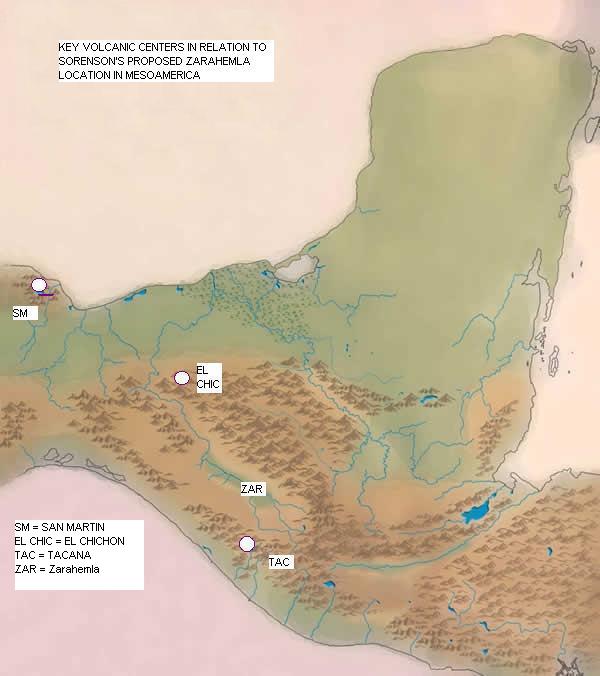
The approximate locations of these three volcanoes — San Martin, El Chichon, and Tacana — are sketched in the thumbnail. They are the volcanoes with the most “punch” in the area of the Sorenson model, and together – but not separately — they could produce the appropriate regional types of destruction noted in the catastrophe, with significant damage in the land southward from Zarahemla, to the “eastern” (Gulf Coast) lands, and into the land northward from Zarahemla.
This is not trivial in evaluating a geographic model of the Book of Mormon. You won’t find evidence of 2000 year old volcanic eruptions in the Mississippi River basin or in upstate New York. You can’t even find the right volcanic evidence in Mesoamerican models that match the Book of Mormon’s Sidon with the Usumacinta River instead of the Grijalva.
So we ought to ask how much of the time these volcanoes could have erupted “simultaneously”, and when those times were. We can never hope to know whether such eruptions began “within the space of three hours” of each other. What we can hope to detect is the radio-carbon ages of organic matter destroyed at the very beginning of the eruptions, when the pyroclastic materials or tephra first reach them. And the uncertainty in such dates for the times of interest here will normally be measured in decades.
The Smithsonian Global Volcanism Program tabulates reports on eruption histories of volcanoes worldwide. They have data on timing and size of eruptions for all three of the above volcanoes that permits identification of whether the three could have produced large eruptions simultaneously as far back as 6585 BCE. In that 8600 year record, there are possible overlaps only about 3% of the time, in two separate eras. In short, it’s a test that is too imprecise to provide positive evidence, but a test that is remarkably easy to fail.
The first possible simultaneous eruption lies between 1230 BCE and 1190 BCE.
The second possible simultaneous eruption lies between 30 BCE and 170 CE.
A remarkably easy geophysical test for the Sorenson Mesoamerican model to fail gets passed.
Comments 21
Great article. I’m actually bored by scientific stuff most of the time, but you were both engaging and informative. Thanks.
A remarkably easy geophysical test — 😉
I like the honesty in that analysis, that the test is remarkably easy. Is it really that easy?
But the article was very interesting, even so. Thanks!
Ethesis:
I think it is remarkably easy to fail. Go to the Smithsonian site linked in the OP and check the menu map of volcanoes in Mexico and Central America. Note how dense they are — except in the center of the area of Sorenson’s model. Almost anywhere else on the ring of fire, there would be lots of overlapping dates of eruptions over the past several thousand years. We aren’t even certain today how many of the Cascade volcanoes in Washington and Oregon were in overlapping eruption in the first part of the 19th Century. So, in most places, you could find several volcanoes in overlapping eruption far more than 3% of the time, and the fact that Sorenson’s discussion concentrates on volcanoes in the Central Valley means that eruptive histories weren’t baked into the Sorenson model to insure much more than 3% of the time would be covered.
There are only 11 known eruptive periods at El Chichon in the last 8000 years, and the 30CE date certainly did not have to fit in one of them. Tacana has no known eruptions in the Smithsonian database between 1190 BCE and 30 BCE.
So I think “easy to fail” is a fair description. 😀
Ah, he meant easy to fail, rather than easy to pass. That explains a lot 😉
I had thought he meant that it was a remarkably easy test to pass, and it really did not seem so easy to me.
I know he said “remarkably easy test to fail” but I got what he meant by that backwards. Was a busy day yesterday. I’ll have to avoid commenting when things are quite so busy.
Most interesting! Well-written for a nonscientist such as myself to understand. Thank you for the research, written analysis, and map of specific points to visualize the events.
My reading of the text concluded that the Book of Mormon was describing multiple volcanic events. That reading made me very interested in your analysis, which is well beyond my expertise. Is there any record of the eruption of those volcanoes in the period when it was possible? The archaeological record seems to show significant results of the eruption of a volcano in San Salvador around AD 250, but I haven’t seen anything on eruptions around AD 30. Obviously, I would be very interested in that evidence. Knowing it is possible is tantalizing, but I would love to have “harder” stuff!
Brant:
See the link to the Smithsonian Global Volcanism Program in the OP and play to your heart’s content. They extract everything they can from the geological literature and summarize it in one place. They, of course, have no interest in details theological or archeological, but if you zero in on a particular volcano of interest, you can hunt through the more specialized literature as you wish.
I assume both the OP and Brant have seen the MI report (and summary) on ice core dating of volcanic eruptions?
http://maxwellinstitute.byu.edu/publications/jbms/?vol=12&num=1&id=309
http://maxwellinstitute.byu.edu/publications/insights/?vol=23&num=6&id=488
Any thoughts on that?
Firetag: What are your thoughts on the cosmic coincidence of these three volcanoes erupting at the moment of Christ’s death. Do you see it as a big plan of God to unleash at just the right dramatic moment or a Noah’esque-type destruction of the wicked, or just a random event.
For me, I don’t like the idea of God as a stage manager trying to get the most dramatic effect. It seems to be too frivolous with the lives of people. Scads of people in SIXTEEN cities were taken before they had a chance to repent. People who were drowned, crushed, and burned to death. For what? Dramatic effect?
Also, my reading of the Smithsonian website has you severely overstating the combined power of the three volcanoes compared with the catastrophic reading of 3 Nephi 8. Only Tacana seemed to have an explosive event large enough to impact a wide area. According to the website, its Volcanic Explosively Index rated a 4, a step below Mt. St. Helen’s 5. The other two seem to be more local, affecting their immediate flanks and local valleys. Maybe enough ash fall to be annoying but not to darken the sky for three days.
But an alternate case could be presented that Nephi over-exaggerated the cataclysm.
I think it’s entirely possible that the records, coming from the ceremonial centers, were closer to the most extreme effects than those in scattered regions round about, and people weren’t moving about much at the time to get up-to-the-minute reports, so the most extreme conditions during the eruptions were prefentially reported. Of course, volcanic eruptions do transmit effects prefentially down the mountainsides and drainage basins (which is why the accessibility of ash and lahars to the Grijalva River (where it can further flood and bury things downstream “northward’ of Zarahemla) is so critical to tying things to the Sorenson model.
The ash clouds from St. Helens (VEI=5) were impressive even in eastern Washington state, according to family friends who lived through it from the Spokane area. (They even brought me ash samples they’d collected from their yard.)
The absense of a VEI measurement for a particular eruption in the Smithsonian data base doesn’t mean the eruption was small; it means the eruption data does not permit identification of a VEI for the event. In general VEI’s of 1 or 2 are undetectable that far back in time, so tha fact that a 2000 year old eruprion is apparent at all tends to say something about size.
Tacana’s VEI for the event of interest is given as “4?” which merely means it was somewhere between 1/20th and 1/2 of St. Helens size — as best anyone can tell.
There is no VEI estimate for the Chichon eruption, but we know that that volcano produced four VEI=5 eruptions both before and after the time of Christ.
There is no VEI estimate associated with the San Martin eruption, although we should expect its eruptions to be less explosive than Chichon because it is a shield volcano (like Hawaii) rather than a young stratovolcano like St. Helens or El Chichon.
You should also bear in mind that the triggering event for a simultaneous eruption within a three hour window would probably involve a thrust earthquake along the Middle American Trench similar in origin to the Chilean earthquake of a few months ago. That latter earthquake was triggering magnitude 6 aftershocks over a region several hundred miles long.
The theological implications of reflecting Christ’s death in the physical world are a bit beyond the scope of this post. In a general sense, I believe in a God whose ideas of love should never be mistaken as a synonym for cuddly. As I’ve said on my blog (and tried to depict in my heading graphic there), God is both creator and destroyer, and He is not playing by our rules.
I believe He is simultaneously compassionate toward even a cancer cell, yet capable of destroying a galaxy. He seems to be interested in helping us experience ALL of the possibilities of our existence, not just the pleasant ones.
Of course, since I also think that modern cosmology forces us to the notion that we have multiple copies of our bodies, that may not be as harsh as it sounds. ;D
Photos taken of Iceland’s Eyjafjallajökull volcano erupting earlier this year show ash and lightning that’s very similar to the Book of Mormon’s description of destruction and darkness.
http://bit.ly/9mcUAA
I had just heard that the Tushar range near Beaver, Utah erupted near 30 AD and carved out the mountains there as we now see them–but that was just speculation. Any evidence?
Peter:
I am aware of no volcanic activity in Utah that can be dated to 30 CE.
That said, there are several volcanic fields in Utah; the entire Basin and Range province in the Western US is a site of active spreading, still poorly understood, and relatively non-explosive magmas sometimes do leak through the crust from below and produce lava flows on the surface. The only Utah activity able to be accurately dated in the Smithsonian database occurred about 1000 years ago. There are undated flows that may be thousands of years older from volcanoes that are not yet considered extinct.
Nice work.
Mike:
Impressive pictures. Those things in the sky anywhere nearby would tend to get one’s attention.
Tom:
Thanks.
Thanks for sharing this. Just for reference, here is Nibley on Book of Mormon Geography. I thought you might be interested in reviewing it.
Good stuff, FireTag! The whole analysis was very thoughtful, but the inclusion of the passing of the easy-to-fail test at the end was just plain artistic.
Thanks to both Greg and Ben.
Greg, I was aware of Nibley’s ideas through Givens’ “By the Hand of Mormon”. Although I ultimately must fall back on my personal testimony, I’m too much of a curious scientist not to nibble at the problem of geography, and to be open to new evidence for or against my own experiences.
I liked the map in your post; I should also take this opportunity to thank Morgan Deane (comment 1) for the original blank Central American map jpg I used above.
No problem FireTag – ultimately it’s all personal anyway.
I like louis vuitton handbags,the women louis vuitton handbag is fashion,if you like,you can enter my web
http://www.mylouisvuittonuk.org